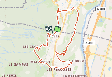
Crêtes de Comboire G1

d.rochas
User

Length
10.7 km

Max alt
586 m

Uphill gradient
510 m
Km-Effort
17.5 km

Min alt
302 m

Downhill gradient
511 m
Boucle
Yes
Creation date :
2024-09-30 15:27:17.744
Updated on :
2024-09-30 15:29:19.513
3h58
Difficulty : Difficult

FREE GPS app for hiking
 SityTrail
IGN / Geographical institutes
SityTrail Plus
The world is yours!
About
Trail Walking of 10.7 km to be discovered at Auvergne-Rhône-Alpes, Isère, Claix. This trail is proposed by d.rochas.
Description
Cossey, Malhivert, La Balme, Belvédère de Comboire
Positioning
Country:
France
Region :
Auvergne-Rhône-Alpes
Department/Province :
Isère
Municipality :
Claix
Location:
Unknown
Start:(Dec)
Start:(UTM)
710051 ; 5002223 (31T) N.
Comments