


Bonnet rouge

Clo0413
User

Length
14.9 km

Max alt
1635 m

Uphill gradient
963 m
Km-Effort
28 km

Min alt
832 m

Downhill gradient
962 m
Boucle
No
Creation date :
2024-09-30 07:33:58.934
Updated on :
2024-09-30 15:38:04.85
4h44
Difficulty : Very difficult

FREE GPS app for hiking
 SityTrail
IGN / Geographical institutes
SityTrail Plus
The world is yours!
About
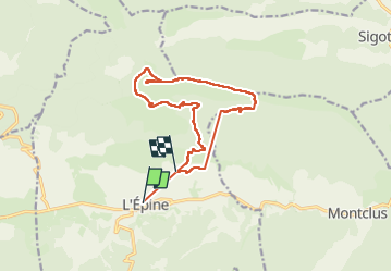
Trail Walking of 14.9 km to be discovered at Provence-Alpes-Côte d'Azur, Hautes-Alpes, L'Épine. This trail is proposed by Clo0413.
Positioning
Country:
France
Region :
Provence-Alpes-Côte d'Azur
Department/Province :
Hautes-Alpes
Municipality :
L'Épine
Location:
Unknown
Start:(Dec)
Start:(UTM)
708188 ; 4921547 (31T) N.
Comments