


Balade du San Peyre

dan69390
User
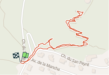

Length
945 m

Max alt
117 m

Uphill gradient
53 m
Km-Effort
1.7 km

Min alt
59 m

Downhill gradient
53 m
Boucle
Yes
Creation date :
2024-10-01 11:48:20.0
Updated on :
2024-10-01 12:43:14.397
54m
Difficulty : Easy

FREE GPS app for hiking
 SityTrail
IGN / Geographical institutes
SityTrail Plus
The world is yours!
About
Trail Walking of 945 m to be discovered at Provence-Alpes-Côte d'Azur, Maritime Alps, Mandelieu-la-Napoule. This trail is proposed by dan69390.
Positioning
Country:
France
Region :
Provence-Alpes-Côte d'Azur
Department/Province :
Maritime Alps
Municipality :
Mandelieu-la-Napoule
Location:
Unknown
Start:(Dec)
Start:(UTM)
333140 ; 4821060 (32T) N.
Comments