


vaugines-cucuron N2

mic-13
User
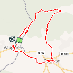

Length
11 km

Max alt
608 m

Uphill gradient
355 m
Km-Effort
15.7 km

Min alt
336 m

Downhill gradient
356 m
Boucle
Yes
Creation date :
2019-04-23 15:56:25.028
Updated on :
2019-04-23 15:56:25.054
3h18
Difficulty : Medium

FREE GPS app for hiking
 SityTrail
IGN / Geographical institutes
SityTrail Plus
The world is yours!
About
Trail Walking of 11 km to be discovered at Provence-Alpes-Côte d'Azur, Vaucluse, Vaugines. This trail is proposed by mic-13.
Positioning
Country:
France
Region :
Provence-Alpes-Côte d'Azur
Department/Province :
Vaucluse
Municipality :
Vaugines
Location:
Unknown
Start:(Dec)
Start:(UTM)
694498 ; 4850173 (31T) N.
Comments