


42-saint-joseph2-18km-590m

bourdevos
User
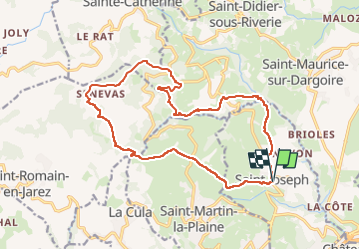

Length
18.1 km

Max alt
784 m

Uphill gradient
592 m
Km-Effort
26 km

Min alt
350 m

Downhill gradient
587 m
Boucle
Yes
Creation date :
2024-09-30 20:46:39.0
Updated on :
2024-10-02 18:03:55.852

FREE GPS app for hiking
 SityTrail
IGN / Geographical institutes
SityTrail Plus
The world is yours!
About
Trail of 18.1 km to be discovered at Auvergne-Rhône-Alpes, Loire, Saint-Joseph. This trail is proposed by bourdevos.
Positioning
Country:
France
Region :
Auvergne-Rhône-Alpes
Department/Province :
Loire
Municipality :
Saint-Joseph
Location:
Unknown
Start:(Dec)
Start:(UTM)
626317 ; 5045916 (31T) N.
Comments