


St Auxile au départ de Callas

mb83serre
User GUIDE
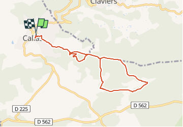

Length
8.8 km

Max alt
449 m

Uphill gradient
293 m
Km-Effort
12.7 km

Min alt
313 m

Downhill gradient
293 m
Boucle
Yes
Creation date :
2024-10-03 14:03:52.49
Updated on :
2024-10-03 14:06:42.7
2h52
Difficulty : Medium

FREE GPS app for hiking
 SityTrail
IGN / Geographical institutes
SityTrail Plus
The world is yours!
About
Trail Walking of 8.8 km to be discovered at Provence-Alpes-Côte d'Azur, Var, Callas. This trail is proposed by mb83serre.
Positioning
Country:
France
Region :
Provence-Alpes-Côte d'Azur
Department/Province :
Var
Municipality :
Callas
Location:
Unknown
Start:(Dec)
Start:(UTM)
301419 ; 4829659 (32T) N.
Comments