


Chagny - Chassagne - Santenay. BS

XavierFaidix
User
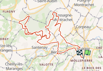

Length
29 km

Max alt
496 m

Uphill gradient
615 m
Km-Effort
37 km

Min alt
204 m

Downhill gradient
615 m
Boucle
Yes
Creation date :
2024-10-03 07:38:14.547
Updated on :
2024-10-03 14:18:32.264
3h38
Difficulty : Difficult

FREE GPS app for hiking
 SityTrail
IGN / Geographical institutes
SityTrail Plus
The world is yours!
About
Trail Mountain bike of 29 km to be discovered at Bourgogne-Franche-Comté, Saône-et-Loire, Chagny. This trail is proposed by XavierFaidix.
Positioning
Country:
France
Region :
Bourgogne-Franche-Comté
Department/Province :
Saône-et-Loire
Municipality :
Chagny
Location:
Unknown
Start:(Dec)
Start:(UTM)
633479 ; 5195754 (31T) N.
Comments