


Pic de Courbayran

lebarça
User
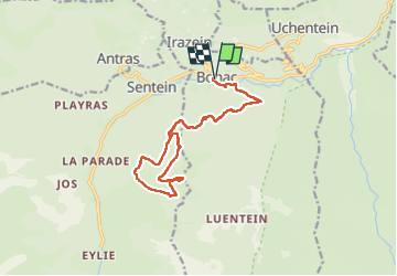

Length
17.5 km

Max alt
1750 m

Uphill gradient
1120 m
Km-Effort
32 km

Min alt
705 m

Downhill gradient
1120 m
Boucle
Yes
Creation date :
2024-10-03 06:50:41.0
Updated on :
2024-10-03 15:38:18.573

FREE GPS app for hiking
 SityTrail
IGN / Geographical institutes
SityTrail Plus
The world is yours!
About
Trail of 17.5 km to be discovered at Occitania, Ariège, Bonac-Irazein. This trail is proposed by lebarça.
Positioning
Country:
France
Region :
Occitania
Department/Province :
Ariège
Municipality :
Bonac-Irazein
Location:
Unknown
Start:(Dec)
Start:(UTM)
334549 ; 4749095 (31T) N.
Comments