


Fontanes

kephas
User
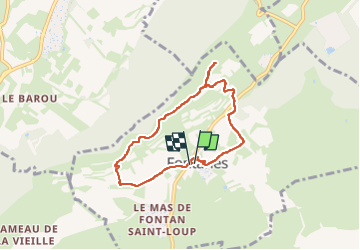

Length
7 km

Max alt
177 m

Uphill gradient
97 m
Km-Effort
8.3 km

Min alt
98 m

Downhill gradient
97 m
Boucle
Yes
Creation date :
2024-10-04 10:00:12.0
Updated on :
2024-10-04 13:59:33.841

FREE GPS app for hiking
 SityTrail
IGN / Geographical institutes
SityTrail Plus
The world is yours!
About
Trail of 7 km to be discovered at Occitania, Hérault, Fontanès. This trail is proposed by kephas.
Description
Petite balade sympa sur de bons chemins au départ de Fontanes
Photos


Positioning
Country:
France
Region :
Occitania
Department/Province :
Hérault
Municipality :
Fontanès
Location:
Unknown
Start:(Dec)
Start:(UTM)
573491 ; 4849372 (31T) N.
Comments