


Chenimenil

JeanPierreNancy
User
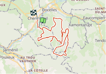

Length
21 km

Max alt
680 m

Uphill gradient
535 m
Km-Effort
29 km

Min alt
367 m

Downhill gradient
561 m
Boucle
No
Creation date :
2024-10-04 11:12:37.8
Updated on :
2024-10-04 14:40:34.282
3h27
Difficulty : Very easy

FREE GPS app for hiking
 SityTrail
IGN / Geographical institutes
SityTrail Plus
The world is yours!
About
Trail Mountain bike of 21 km to be discovered at Grand Est, Vosges, Cheniménil. This trail is proposed by JeanPierreNancy.
Positioning
Country:
France
Region :
Grand Est
Department/Province :
Vosges
Municipality :
Cheniménil
Location:
Unknown
Start:(Dec)
Start:(UTM)
321838 ; 5333703 (32U) N.
Comments