


tour du Ventoux Malaucène St Léger

taguette
User
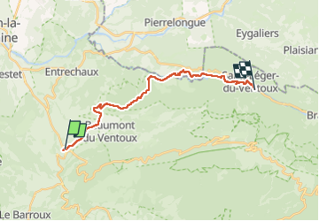

Length
21 km

Max alt
559 m

Uphill gradient
614 m
Km-Effort
28 km

Min alt
315 m

Downhill gradient
534 m
Boucle
No
Creation date :
2024-10-04 07:38:23.514
Updated on :
2024-10-04 15:13:07.89
7h30
Difficulty : Very difficult

FREE GPS app for hiking
 SityTrail
IGN / Geographical institutes
SityTrail Plus
The world is yours!
About
Trail Walking of 21 km to be discovered at Provence-Alpes-Côte d'Azur, Vaucluse, Malaucène. This trail is proposed by taguette.
Positioning
Country:
France
Region :
Provence-Alpes-Côte d'Azur
Department/Province :
Vaucluse
Municipality :
Malaucène
Location:
Unknown
Start:(Dec)
Start:(UTM)
670395 ; 4893419 (31T) N.
Comments