


FORÊT SÉNART 5

hrpatu
User
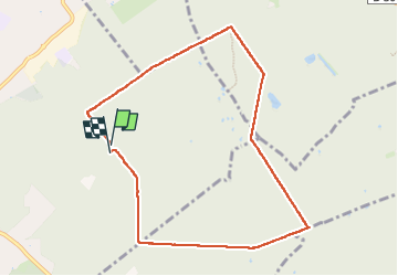

Length
8.3 km

Max alt
97 m

Uphill gradient
49 m
Km-Effort
9 km

Min alt
83 m

Downhill gradient
50 m
Boucle
Yes
Creation date :
2024-10-04 12:33:02.302
Updated on :
2024-10-04 15:50:40.229
1h46
Difficulty : Easy

FREE GPS app for hiking
 SityTrail
IGN / Geographical institutes
SityTrail Plus
The world is yours!
About
Trail Walking of 8.3 km to be discovered at Ile-de-France, Essonne, Draveil. This trail is proposed by hrpatu.
Positioning
Country:
France
Region :
Ile-de-France
Department/Province :
Essonne
Municipality :
Draveil
Location:
Unknown
Start:(Dec)
Start:(UTM)
458832 ; 5391160 (31U) N.
Comments