


bagnols marche 2024

mthomas30
User
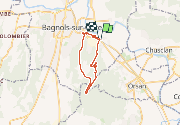

Length
10.5 km

Max alt
237 m

Uphill gradient
231 m
Km-Effort
13.6 km

Min alt
44 m

Downhill gradient
231 m
Boucle
Yes
Creation date :
2024-09-29 06:40:00.126
Updated on :
2024-10-05 05:55:50.799
2h29
Difficulty : Medium

FREE GPS app for hiking
 SityTrail
IGN / Geographical institutes
SityTrail Plus
The world is yours!
About
Trail Walking of 10.5 km to be discovered at Occitania, Gard, Bagnols-sur-Cèze. This trail is proposed by mthomas30.
Positioning
Country:
France
Region :
Occitania
Department/Province :
Gard
Municipality :
Bagnols-sur-Cèze
Location:
Unknown
Start:(Dec)
Start:(UTM)
631428 ; 4890345 (31T) N.
Comments