


col de reyret express

veroarvinberod
User
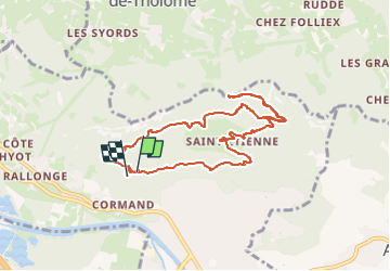

Length
9.1 km

Max alt
957 m

Uphill gradient
451 m
Km-Effort
15.2 km

Min alt
591 m

Downhill gradient
465 m
Boucle
Yes
Creation date :
2024-10-06 12:17:35.144
Updated on :
2024-10-06 13:54:19.496
1h36
Difficulty : Easy

FREE GPS app for hiking
 SityTrail
IGN / Geographical institutes
SityTrail Plus
The world is yours!
About
Trail Mountain bike of 9.1 km to be discovered at Auvergne-Rhône-Alpes, Upper Savoy, Bonneville. This trail is proposed by veroarvinberod.
Positioning
Country:
France
Region :
Auvergne-Rhône-Alpes
Department/Province :
Upper Savoy
Municipality :
Bonneville
Location:
Unknown
Start:(Dec)
Start:(UTM)
298658 ; 5107485 (32T) N.
Comments