


lac ausseilla

chasle
User
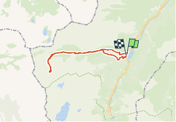

Length
15.3 km

Max alt
2208 m

Uphill gradient
1010 m
Km-Effort
29 km

Min alt
1214 m

Downhill gradient
1015 m
Boucle
Yes
Creation date :
2024-10-06 06:43:14.119
Updated on :
2024-10-06 18:01:44.361
5h06
Difficulty : Difficult

FREE GPS app for hiking
 SityTrail
IGN / Geographical institutes
SityTrail Plus
The world is yours!
About
Trail Walking of 15.3 km to be discovered at Occitania, Hautespyrenees, Arrens-Marsous. This trail is proposed by chasle.
Positioning
Country:
France
Region :
Occitania
Department/Province :
Hautespyrenees
Municipality :
Arrens-Marsous
Location:
Unknown
Start:(Dec)
Start:(UTM)
723735 ; 4754892 (30T) N.
Comments