


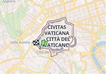
Tour du vatican

Charles Kirsch
User

Length
3.4 km

Max alt
77 m

Uphill gradient
66 m
Km-Effort
4.3 km

Min alt
18 m

Downhill gradient
69 m
Boucle
Yes
Creation date :
2024-10-07 06:48:32.99
Updated on :
2024-10-07 07:23:05.756
28m
Difficulty : Very easy

FREE GPS app for hiking
 SityTrail
IGN / Geographical institutes
SityTrail Plus
The world is yours!
About
Trail Running of 3.4 km to be discovered at Lazio, Roma Capitale, Rome. This trail is proposed by Charles Kirsch.
Positioning
Country:
Italy
Region :
Lazio
Department/Province :
Roma Capitale
Municipality :
Rome
Location:
Unknown
Start:(Dec)
Start:(UTM)
288314 ; 4641869 (33T) N.
Comments