


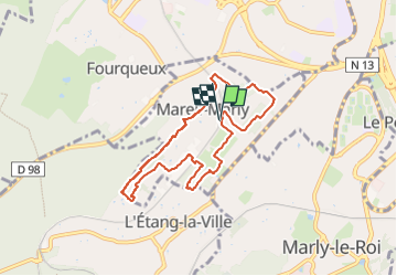
Les sentes de Mareil-Marly

Rando MLC
User

Length
6.8 km

Max alt
165 m

Uphill gradient
143 m
Km-Effort
8.7 km

Min alt
61 m

Downhill gradient
147 m
Boucle
Yes
Creation date :
2024-10-07 12:29:14.336
Updated on :
2025-03-09 17:09:56.524
1h59
Difficulty : Medium

FREE GPS app for hiking
 SityTrail
IGN / Geographical institutes
SityTrail Plus
The world is yours!
About
Trail Walking of 6.8 km to be discovered at Ile-de-France, Yvelines, Mareil-Marly. This trail is proposed by Rando MLC.
Description
Cet itinéraire est trompeur. La ville n’est pas loin, mais c’est bucolique à souhait : bois et vergers, village qui a gardé ses vieilles pierres, vignes en embuscade.


Positioning
Country:
France
Region :
Ile-de-France
Department/Province :
Yvelines
Municipality :
Mareil-Marly
Location:
Unknown
Start:(Dec)
Start:(UTM)
432578 ; 5414702 (31U) N.
Comments