


NSB5-MazauguesPivaut-190424

mb83serre
User GUIDE
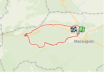

Length
16.1 km

Max alt
744 m

Uphill gradient
424 m
Km-Effort
22 km

Min alt
369 m

Downhill gradient
423 m
Boucle
Yes
Creation date :
2024-10-08 07:09:56.56
Updated on :
2024-10-08 07:15:19.737
4h56
Difficulty : Medium

FREE GPS app for hiking
 SityTrail
IGN / Geographical institutes
SityTrail Plus
The world is yours!
About
Trail Walking of 16.1 km to be discovered at Provence-Alpes-Côte d'Azur, Var, Mazaugues. This trail is proposed by mb83serre.
Description
grp_trc:
Positioning
Country:
France
Region :
Provence-Alpes-Côte d'Azur
Department/Province :
Var
Municipality :
Mazaugues
Location:
Unknown
Start:(Dec)
Start:(UTM)
736171 ; 4803998 (31T) N.
Comments