


stade Vauchassis

evelyne10
User
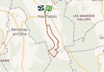

Length
10 km

Max alt
278 m

Uphill gradient
134 m
Km-Effort
11.8 km

Min alt
184 m

Downhill gradient
135 m
Boucle
Yes
Creation date :
2024-10-08 07:01:58.679
Updated on :
2024-10-08 09:57:15.291
2h54
Difficulty : Very easy

FREE GPS app for hiking
 SityTrail
IGN / Geographical institutes
SityTrail Plus
The world is yours!
About
Trail Walking of 10 km to be discovered at Grand Est, Aube, Vauchassis. This trail is proposed by evelyne10.
Positioning
Country:
France
Region :
Grand Est
Department/Province :
Aube
Municipality :
Vauchassis
Location:
Unknown
Start:(Dec)
Start:(UTM)
568456 ; 5341418 (31U) N.
Comments