


les méandres de l'Orbiel

Mascart
User
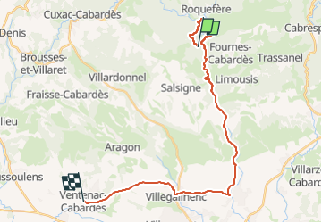

Length
28 km

Max alt
461 m

Uphill gradient
373 m
Km-Effort
33 km

Min alt
123 m

Downhill gradient
573 m
Boucle
No
Creation date :
2024-10-08 11:38:44.051
Updated on :
2024-10-08 15:57:13.98
2h52
Difficulty : Medium

FREE GPS app for hiking
 SityTrail
IGN / Geographical institutes
SityTrail Plus
The world is yours!
About
Trail Walking of 28 km to be discovered at Occitania, Aude, Les Ilhes. This trail is proposed by Mascart.
Description
départ des Ilhes-boucle via Bordeneuve puis la Grave
Positioning
Country:
France
Region :
Occitania
Department/Province :
Aude
Municipality :
Les Ilhes
Location:
Unknown
Start:(Dec)
Start:(UTM)
449128 ; 4800090 (31T) N.
Comments