


villard de lans 2

Mariolebeno
User

Length
12.1 km

Max alt
2011 m

Uphill gradient
1053 m
Km-Effort
26 km

Min alt
1173 m

Downhill gradient
1039 m
Boucle
Yes
Creation date :
2024-10-08 16:20:44.213
Updated on :
2024-10-08 16:20:47.973
5h56
Difficulty : Very difficult

FREE GPS app for hiking
 SityTrail
IGN / Geographical institutes
SityTrail Plus
The world is yours!
About
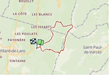
Trail Walking of 12.1 km to be discovered at Auvergne-Rhône-Alpes, Isère, Villard-de-Lans. This trail is proposed by Mariolebeno.
Positioning
Country:
France
Region :
Auvergne-Rhône-Alpes
Department/Province :
Isère
Municipality :
Villard-de-Lans
Location:
Unknown
Start:(Dec)
Start:(UTM)
703019 ; 4994183 (31T) N.
Comments