


2024-10-08_19h50m42_J 7 1

LUTZMarc
User

Length
16 km

Max alt
262 m

Uphill gradient
219 m
Km-Effort
18.9 km

Min alt
181 m

Downhill gradient
220 m
Boucle
Yes
Creation date :
2024-10-08 17:50:42.668
Updated on :
2024-11-01 07:53:27.028
4h17
Difficulty : Easy

FREE GPS app for hiking
 SityTrail
IGN / Geographical institutes
SityTrail Plus
The world is yours!
About
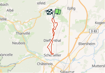
Trail Walking of 16 km to be discovered at Grand Est, Bas-Rhin, Blienschwiller. This trail is proposed by LUTZMarc.
Description
Boucle facile à travers le vignoble.
Positioning
Country:
France
Region :
Grand Est
Department/Province :
Bas-Rhin
Municipality :
Blienschwiller
Location:
Unknown
Start:(Dec)
Start:(UTM)
383091 ; 5355758 (32U) N.
Comments
rando automnale dans le vignoble .