


tour Ventoux Sault Mt Serein par sommet

taguette
User
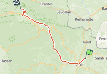

Length
24 km

Max alt
1907 m

Uphill gradient
1286 m
Km-Effort
39 km

Min alt
682 m

Downhill gradient
672 m
Boucle
No
Creation date :
2024-10-10 05:55:03.625
Updated on :
2024-10-10 13:56:01.151
8h00
Difficulty : Very difficult

FREE GPS app for hiking
 SityTrail
IGN / Geographical institutes
SityTrail Plus
The world is yours!
About
Trail Walking of 24 km to be discovered at Provence-Alpes-Côte d'Azur, Vaucluse, Sault. This trail is proposed by taguette.
Positioning
Country:
France
Region :
Provence-Alpes-Côte d'Azur
Department/Province :
Vaucluse
Municipality :
Sault
Location:
Unknown
Start:(Dec)
Start:(UTM)
693980 ; 4885977 (31T) N.
Comments