


serre du mouton

orsel
User GUIDE
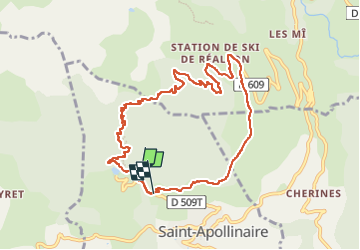

Length
10.2 km

Max alt
1892 m

Uphill gradient
522 m
Km-Effort
17.3 km

Min alt
1396 m

Downhill gradient
547 m
Boucle
No
Creation date :
2024-10-11 08:48:06.641
Updated on :
2024-10-11 14:43:00.819
4h53
Difficulty : Easy

FREE GPS app for hiking
 SityTrail
IGN / Geographical institutes
SityTrail Plus
The world is yours!
About
Trail Walking of 10.2 km to be discovered at Provence-Alpes-Côte d'Azur, Hautes-Alpes, Saint-Apollinaire. This trail is proposed by orsel.
Positioning
Country:
France
Region :
Provence-Alpes-Côte d'Azur
Department/Province :
Hautes-Alpes
Municipality :
Saint-Apollinaire
Location:
Unknown
Start:(Dec)
Start:(UTM)
289561 ; 4937668 (32T) N.
Comments