


tour du Ventoux Mont Serein Montbrun

taguette
User
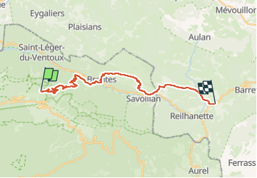

Length
24 km

Max alt
1428 m

Uphill gradient
654 m
Km-Effort
35 km

Min alt
460 m

Downhill gradient
1459 m
Boucle
No
Creation date :
2024-10-11 07:30:34.113
Updated on :
2024-10-11 15:04:41.872
7h33
Difficulty : Very difficult

FREE GPS app for hiking
 SityTrail
IGN / Geographical institutes
SityTrail Plus
The world is yours!
About
Trail Walking of 24 km to be discovered at Provence-Alpes-Côte d'Azur, Vaucluse, Beaumont-du-Ventoux. This trail is proposed by taguette.
Positioning
Country:
France
Region :
Provence-Alpes-Côte d'Azur
Department/Province :
Vaucluse
Municipality :
Beaumont-du-Ventoux
Location:
Unknown
Start:(Dec)
Start:(UTM)
681870 ; 4894925 (31T) N.
Comments