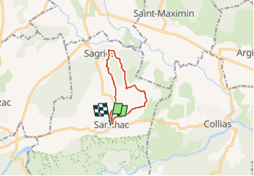
Trail Walking Sanilhac-Sagriès - SANILHAC-SAGRIES - Photo
© OpenStreetMap contributors
Length
Length
8.4 km
Max alt
Max alt
151 m
Uphill gradient
Uphill gradient
140 m
Km-Effort
Km-Effort  
10.3 km
Min alt
Min alt
69 m
Downhill gradient
Downhill gradient
141 m
Boucle
Boucle
Yes
Creation date :
2024-10-11 18:54:23.018
Updated on :
2024-10-11 19:01:15.929

(1 Reviews)

Walking
Walking
2h20
Difficulty : Medium

Scan this QR Code to open this trail in the SityTrail application

FREE GPS app for hiking

Logo SityTrail SityTrail

IGN / Geographical institutes

Download SityTrail from the App Store Download SityTrail from Google Play

Logo SityTrail SityTrail Plus

The world is yours!

Download SityTrail from the App Store Download SityTrail from Google Play Download SityTrail on Huawei AppGallery

About

Trail Walking of 8.4 km to be discovered at Occitania, Gard, Sanilhac-Sagriès. This trail is proposed by rando30129.

Description

Sentier des fileuses
Le sentier évolue dans un cadre agréable et longe des sculptures originales en bois, un hommage aux femmes et aux enfants travaillant au XIXe siècle à la filature Théraube à Uzès, aujourd'hui devenue le Musée du Bonbon.

Elevation profile

Positioning

Country:
France
Region :
Occitania
Department/Province :
Gard
Municipality :
Sanilhac-Sagriès
Location:
Unknown
Start:(UTM)
614336 ; 4867738 (31T) N.

Comments

Please log in to post a review or rate the element


Close
My subscriptions