


lanzarote 13/10/24

hartmannpat
User

Length
2.1 km

Max alt
50 m

Uphill gradient
45 m
Km-Effort
2.7 km

Min alt
13 m

Downhill gradient
45 m
Boucle
Yes
Creation date :
2024-10-12 07:36:06.558
Updated on :
2024-10-12 08:08:49.81
29m
Difficulty : Very easy

FREE GPS app for hiking
 SityTrail
IGN / Geographical institutes
SityTrail Plus
The world is yours!
About
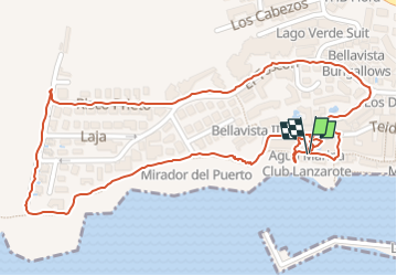
Trail Walking of 2.1 km to be discovered at Canary Islands, Las Palmas, Tías. This trail is proposed by hartmannpat.
Positioning
Country:
Spain
Region :
Canary Islands
Department/Province :
Las Palmas
Municipality :
Tías
Location:
Unknown
Start:(Dec)
Start:(UTM)
629110 ; 3200067 (28R) N.
Comments