


tour Ventoux Sault Montbrun

taguette
User
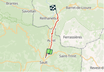

Length
10.5 km

Max alt
842 m

Uphill gradient
190 m
Km-Effort
13.7 km

Min alt
593 m

Downhill gradient
400 m
Boucle
No
Creation date :
2024-10-13 06:31:19.3
Updated on :
2024-10-13 08:55:30.387
2h23
Difficulty : Difficult

FREE GPS app for hiking
 SityTrail
IGN / Geographical institutes
SityTrail Plus
The world is yours!
About
Trail Walking of 10.5 km to be discovered at Provence-Alpes-Côte d'Azur, Vaucluse, Sault. This trail is proposed by taguette.
Positioning
Country:
France
Region :
Provence-Alpes-Côte d'Azur
Department/Province :
Vaucluse
Municipality :
Sault
Location:
Unknown
Start:(Dec)
Start:(UTM)
693138 ; 4885731 (31T) N.
Comments