


Yport/ Vattetot-sur-Mer

geoffrayLayeux
User
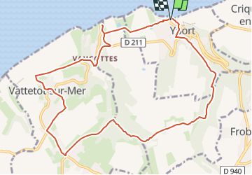

Length
10.9 km

Max alt
98 m

Uphill gradient
220 m
Km-Effort
13.8 km

Min alt
10 m

Downhill gradient
222 m
Boucle
Yes
Creation date :
2024-10-13 12:25:37.057
Updated on :
2024-10-13 12:26:43.998
3h08
Difficulty : Difficult

FREE GPS app for hiking
 SityTrail
IGN / Geographical institutes
SityTrail Plus
The world is yours!
About
Trail Walking of 10.9 km to be discovered at Normandy, Seine-Maritime, Yport. This trail is proposed by geoffrayLayeux.
Positioning
Country:
France
Region :
Normandy
Department/Province :
Seine-Maritime
Municipality :
Yport
Location:
Unknown
Start:(Dec)
Start:(UTM)
306233 ; 5513147 (31U) N.
Comments
attention chemin inaccessible entre le camping La chênaie " et la station d'eau potable : voie privée, interdite