


St-Pierre-en-Port/ Valleuse d'Eletot

geoffrayLayeux
User
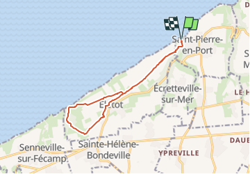

Length
11.7 km

Max alt
114 m

Uphill gradient
175 m
Km-Effort
14 km

Min alt
4 m

Downhill gradient
175 m
Boucle
Yes
Creation date :
2024-10-13 12:37:33.821
Updated on :
2024-10-13 12:38:33.454
3h11
Difficulty : Difficult

FREE GPS app for hiking
 SityTrail
IGN / Geographical institutes
SityTrail Plus
The world is yours!
About
Trail Walking of 11.7 km to be discovered at Normandy, Seine-Maritime, Saint-Pierre-en-Port. This trail is proposed by geoffrayLayeux.
Positioning
Country:
France
Region :
Normandy
Department/Province :
Seine-Maritime
Municipality :
Saint-Pierre-en-Port
Location:
Unknown
Start:(Dec)
Start:(UTM)
319176 ; 5520368 (31U) N.
Comments