


chemin d ambel retour pic Touleau

verozerr
User
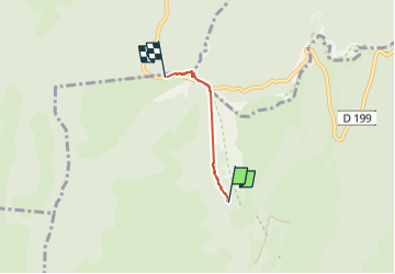

Length
2.4 km

Max alt
1356 m

Uphill gradient
84 m
Km-Effort
3.4 km

Min alt
1271 m

Downhill gradient
56 m
Boucle
No
Creation date :
2024-09-20 15:26:13.573
Updated on :
2024-10-13 13:21:27.973
37m
Difficulty : Easy

FREE GPS app for hiking
 SityTrail
IGN / Geographical institutes
SityTrail Plus
The world is yours!
About
Trail Walking of 2.4 km to be discovered at Auvergne-Rhône-Alpes, Drôme, Omblèze. This trail is proposed by verozerr.
Description
chemin d Ambel
Positioning
Country:
France
Region :
Auvergne-Rhône-Alpes
Department/Province :
Drôme
Municipality :
Omblèze
Location:
Unknown
Start:(Dec)
Start:(UTM)
676647 ; 4972637 (31T) N.
Comments