


mené sentier des gardes

veroarvinberod
User

Length
28 km

Max alt
1375 m

Uphill gradient
1402 m
Km-Effort
46 km

Min alt
644 m

Downhill gradient
1403 m
Boucle
Yes
Creation date :
2024-10-14 09:26:50.031
Updated on :
2024-10-14 14:06:04.685
4h38
Difficulty : Very difficult

FREE GPS app for hiking
 SityTrail
IGN / Geographical institutes
SityTrail Plus
The world is yours!
About
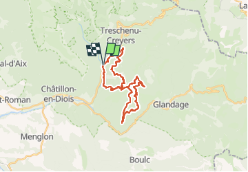
Trail Mountain bike of 28 km to be discovered at Auvergne-Rhône-Alpes, Drôme, Châtillon-en-Diois. This trail is proposed by veroarvinberod.
Positioning
Country:
France
Region :
Auvergne-Rhône-Alpes
Department/Province :
Drôme
Municipality :
Châtillon-en-Diois
Location:
Treschenu-Creyers
Start:(Dec)
Start:(UTM)
700430 ; 4954481 (31T) N.
Comments