


tour Mont Ventoux Sault Methamis

taguette
User
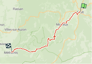

Length
27 km

Max alt
867 m

Uphill gradient
706 m
Km-Effort
38 km

Min alt
282 m

Downhill gradient
1152 m
Boucle
No
Creation date :
2024-10-14 06:22:14.995
Updated on :
2024-10-14 14:08:32.823
7h45
Difficulty : Very difficult

FREE GPS app for hiking
 SityTrail
IGN / Geographical institutes
SityTrail Plus
The world is yours!
About
Trail Walking of 27 km to be discovered at Provence-Alpes-Côte d'Azur, Vaucluse, Sault. This trail is proposed by taguette.
Positioning
Country:
France
Region :
Provence-Alpes-Côte d'Azur
Department/Province :
Vaucluse
Municipality :
Sault
Location:
Unknown
Start:(Dec)
Start:(UTM)
692840 ; 4884989 (31T) N.
Comments