


ST JULIEN 2

bouscaillou
User
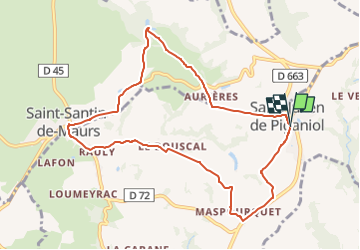

Length
9.7 km

Max alt
401 m

Uphill gradient
197 m
Km-Effort
12.3 km

Min alt
288 m

Downhill gradient
198 m
Boucle
Yes
Creation date :
2024-10-14 17:49:29.525
Updated on :
2024-10-14 17:50:10.229
2h47
Difficulty : Difficult

FREE GPS app for hiking
 SityTrail
IGN / Geographical institutes
SityTrail Plus
The world is yours!
About
Trail Walking of 9.7 km to be discovered at Occitania, Aveyron, Saint-Santin. This trail is proposed by bouscaillou.
Positioning
Country:
France
Region :
Occitania
Department/Province :
Aveyron
Municipality :
Saint-Santin
Location:
Unknown
Start:(Dec)
Start:(UTM)
440878 ; 4944430 (31T) N.
Comments