


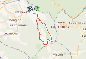
2024-10-15_15h05m22_FFRandonnée-La_Grésière

collot
User


5h13
Difficulty : Medium

FREE GPS app for hiking
 SityTrail
IGN / Geographical institutes
SityTrail Plus
The world is yours!
About
Trail Walking of 11.9 km to be discovered at Auvergne-Rhône-Alpes, Drôme, Menglon. This trail is proposed by collot.
Description
La marche d’approche par le vallon du Mian et le bois du Fays permet progressivement d’atteindre la partie sommitale très pentue de la Grésière. La vue y est spectaculaire, à 360°. La descente emprunte un tunnel creusé dans la roche.
Positioning
Comments