


col de du vialet

darranger
User
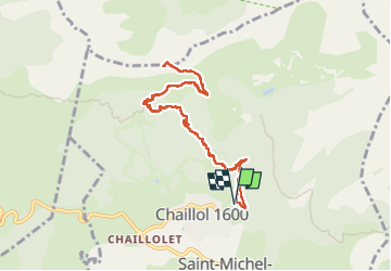

Length
10.1 km

Max alt
2239 m

Uphill gradient
601 m
Km-Effort
18.1 km

Min alt
1631 m

Downhill gradient
603 m
Boucle
Yes
Creation date :
2024-10-15 07:57:02.541
Updated on :
2024-10-15 13:59:43.053
3h16
Difficulty : Difficult

FREE GPS app for hiking
 SityTrail
IGN / Geographical institutes
SityTrail Plus
The world is yours!
About
Trail Walking of 10.1 km to be discovered at Provence-Alpes-Côte d'Azur, Hautes-Alpes, Saint-Michel-de-Chaillol. This trail is proposed by darranger.
Positioning
Country:
France
Region :
Provence-Alpes-Côte d'Azur
Department/Province :
Hautes-Alpes
Municipality :
Saint-Michel-de-Chaillol
Location:
Unknown
Start:(Dec)
Start:(UTM)
275637 ; 4952381 (32T) N.
Comments