


valiguieres

Andre Alarcon
User
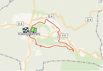

Length
6.9 km

Max alt
201 m

Uphill gradient
98 m
Km-Effort
8.2 km

Min alt
121 m

Downhill gradient
98 m
Boucle
Yes
Creation date :
2024-10-15 11:52:52.612
Updated on :
2024-10-15 14:41:19.554
2h47
Difficulty : Medium

FREE GPS app for hiking
 SityTrail
IGN / Geographical institutes
SityTrail Plus
The world is yours!
About
Trail Walking of 6.9 km to be discovered at Occitania, Gard, Valliguières. This trail is proposed by Andre Alarcon.
Positioning
Country:
France
Region :
Occitania
Department/Province :
Gard
Municipality :
Valliguières
Location:
Unknown
Start:(Dec)
Start:(UTM)
626609 ; 4873688 (31T) N.
Comments