


Enregistrement du 28/04/2023-16646957

Gpoujade
User
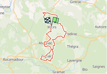

Length
34 km

Max alt
429 m

Uphill gradient
768 m
Km-Effort
44 km

Min alt
247 m

Downhill gradient
762 m
Boucle
Yes
Creation date :
2024-10-15 15:03:11.453
Updated on :
2024-10-17 14:22:53.812
3h04
Difficulty : Very difficult

FREE GPS app for hiking
 SityTrail
IGN / Geographical institutes
SityTrail Plus
The world is yours!
About
Trail Mountain bike of 34 km to be discovered at Occitania, Lot, Miers. This trail is proposed by Gpoujade.
Description
Boucle au départ de Miers : Rignac , Alvignac


Positioning
Country:
France
Region :
Occitania
Department/Province :
Lot
Municipality :
Miers
Location:
Unknown
Start:(Dec)
Start:(UTM)
397869 ; 4967461 (31T) N.
Comments