


pointe Camara

claudel
User
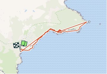

Length
8.6 km

Max alt
67 m

Uphill gradient
215 m
Km-Effort
11.4 km

Min alt
0 m

Downhill gradient
223 m
Boucle
Yes
Creation date :
2024-09-30 09:03:51.733
Updated on :
2024-10-16 09:02:06.335
3h57
Difficulty : Medium

FREE GPS app for hiking
 SityTrail
IGN / Geographical institutes
SityTrail Plus
The world is yours!
About
Trail Walking of 8.6 km to be discovered at Provence-Alpes-Côte d'Azur, Var, Ramatuelle. This trail is proposed by claudel.
Positioning
Country:
France
Region :
Provence-Alpes-Côte d'Azur
Department/Province :
Var
Municipality :
Ramatuelle
Location:
Unknown
Start:(Dec)
Start:(UTM)
308409 ; 4784393 (32T) N.
Comments