


tour du Ventoux Malaucène Bédouin

taguette
User
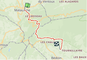

Length
10.6 km

Max alt
699 m

Uphill gradient
496 m
Km-Effort
17.2 km

Min alt
338 m

Downhill gradient
482 m
Boucle
No
Creation date :
2024-10-16 07:14:59.634
Updated on :
2024-10-16 10:30:16.952
3h14
Difficulty : Difficult

FREE GPS app for hiking
 SityTrail
IGN / Geographical institutes
SityTrail Plus
The world is yours!
About
Trail Walking of 10.6 km to be discovered at Provence-Alpes-Côte d'Azur, Vaucluse, Malaucène. This trail is proposed by taguette.
Positioning
Country:
France
Region :
Provence-Alpes-Côte d'Azur
Department/Province :
Vaucluse
Municipality :
Malaucène
Location:
Unknown
Start:(Dec)
Start:(UTM)
670674 ; 4893289 (31T) N.
Comments