


mille étangs 3

Alain28/01
User

Length
14.7 km

Max alt
708 m

Uphill gradient
293 m
Km-Effort
18.6 km

Min alt
540 m

Downhill gradient
289 m
Boucle
Yes
Creation date :
2024-10-18 08:39:56.678
Updated on :
2024-10-18 14:32:40.302
3h37
Difficulty : Medium

FREE GPS app for hiking
 SityTrail
IGN / Geographical institutes
SityTrail Plus
The world is yours!
About
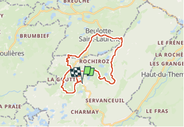
Trail Walking of 14.7 km to be discovered at Bourgogne-Franche-Comté, Haute-Saône, Servance-Miellin. This trail is proposed by Alain28/01.
Positioning
Country:
France
Region :
Bourgogne-Franche-Comté
Department/Province :
Haute-Saône
Municipality :
Servance-Miellin
Location:
Servance
Start:(Dec)
Start:(UTM)
325364 ; 5301030 (32T) N.
Comments