


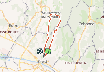
Crest Vosnaveys

meillon
User

Length
10.7 km

Max alt
400 m

Uphill gradient
277 m
Km-Effort
14.4 km

Min alt
266 m

Downhill gradient
279 m
Boucle
Yes
Creation date :
2024-10-19 09:38:38.095
Updated on :
2024-10-19 14:14:09.059
4h34
Difficulty : Easy

FREE GPS app for hiking
 SityTrail
IGN / Geographical institutes
SityTrail Plus
The world is yours!
About
Trail Walking of 10.7 km to be discovered at Auvergne-Rhône-Alpes, Drôme, Crest. This trail is proposed by meillon.
Description
belles vues au depart et a l arrivee sur Les tris becs et le synclinal de Saou
Positioning
Country:
France
Region :
Auvergne-Rhône-Alpes
Department/Province :
Drôme
Municipality :
Crest
Location:
Unknown
Start:(Dec)
Start:(UTM)
660375 ; 4955115 (31T) N.
Comments