


santona

LouisROGER
User GUIDE
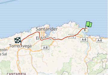

Length
78 km

Max alt
166 m

Uphill gradient
1215 m
Km-Effort
94 km

Min alt
-2 m

Downhill gradient
1156 m
Boucle
No
Creation date :
2024-10-19 08:13:14.034
Updated on :
2024-10-19 15:39:32.939
7h25
Difficulty : Very difficult

FREE GPS app for hiking
 SityTrail
IGN / Geographical institutes
SityTrail Plus
The world is yours!
About
Trail Walking of 78 km to be discovered at Cantabria, Cantabria, Santoña. This trail is proposed by LouisROGER.
Positioning
Country:
Spain
Region :
Cantabria
Department/Province :
Cantabria
Municipality :
Santoña
Location:
Unknown
Start:(Dec)
Start:(UTM)
462739 ; 4810354 (30T) N.
Comments