


cotignac court

bernir
User
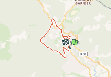

Length
6.7 km

Max alt
387 m

Uphill gradient
192 m
Km-Effort
9.3 km

Min alt
219 m

Downhill gradient
193 m
Boucle
Yes
Creation date :
2024-10-19 17:19:33.405
Updated on :
2024-10-19 17:32:03.787
2h06
Difficulty : Easy

FREE GPS app for hiking
 SityTrail
IGN / Geographical institutes
SityTrail Plus
The world is yours!
About
Trail Walking of 6.7 km to be discovered at Provence-Alpes-Côte d'Azur, Var, Cotignac. This trail is proposed by bernir.
Positioning
Country:
France
Region :
Provence-Alpes-Côte d'Azur
Department/Province :
Var
Municipality :
Cotignac
Location:
Unknown
Start:(Dec)
Start:(UTM)
269681 ; 4823067 (32T) N.
Comments