


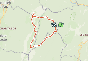
Chartreuse Sure Col d’Hurtierr

c.gourme
User

Length
15.2 km

Max alt
1907 m

Uphill gradient
989 m
Km-Effort
28 km

Min alt
1292 m

Downhill gradient
990 m
Boucle
Yes
Creation date :
2024-10-19 06:44:58.0
Updated on :
2024-10-20 09:10:14.225
8h48
Difficulty : Difficult

FREE GPS app for hiking
 SityTrail
IGN / Geographical institutes
SityTrail Plus
The world is yours!
About
Trail Walking of 15.2 km to be discovered at Auvergne-Rhône-Alpes, Isère, Saint-Pierre-de-Chartreuse. This trail is proposed by c.gourme.
Positioning
Country:
France
Region :
Auvergne-Rhône-Alpes
Department/Province :
Isère
Municipality :
Saint-Pierre-de-Chartreuse
Location:
Unknown
Start:(Dec)
Start:(UTM)
714681 ; 5022679 (31T) N.
Comments