


suences midi

LouisROGER
User GUIDE
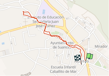

Length
1.2 km

Max alt
98 m

Uphill gradient
6 m
Km-Effort
1.2 km

Min alt
91 m

Downhill gradient
6 m
Boucle
Yes
Creation date :
2024-10-20 08:50:33.045
Updated on :
2024-10-20 09:23:28.086
32m
Difficulty : Easy

FREE GPS app for hiking
 SityTrail
IGN / Geographical institutes
SityTrail Plus
The world is yours!
About
Trail Walking of 1.2 km to be discovered at Cantabria, Cantabria, Suances. This trail is proposed by LouisROGER.
Positioning
Country:
Spain
Region :
Cantabria
Department/Province :
Cantabria
Municipality :
Suances
Location:
Unknown
Start:(Dec)
Start:(UTM)
415779 ; 4808516 (30T) N.
Comments