


Château-Thierry du 20-10-2024

VANDERPUTTENMi
User GUIDE
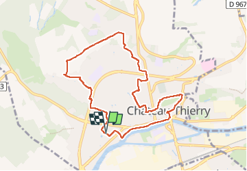

Length
8.5 km

Max alt
184 m

Uphill gradient
163 m
Km-Effort
10.6 km

Min alt
57 m

Downhill gradient
164 m
Boucle
Yes
Creation date :
2024-10-20 06:35:50.153
Updated on :
2024-10-20 14:35:16.151
2h25
Difficulty : Medium

FREE GPS app for hiking
 SityTrail
IGN / Geographical institutes
SityTrail Plus
The world is yours!
About
Trail Walking of 8.5 km to be discovered at Hauts-de-France, Aisne, Château-Thierry. This trail is proposed by VANDERPUTTENMi.
Description
Randonnée "sur les pas de La Fontaine".
Photos


Positioning
Country:
France
Region :
Hauts-de-France
Department/Province :
Aisne
Municipality :
Château-Thierry
Location:
Unknown
Start:(Dec)
Start:(UTM)
528279 ; 5432197 (31U) N.
Comments