


Sarrat de Broucous 2

chasle
User
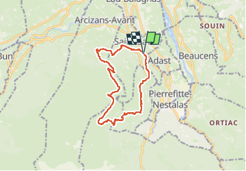

Length
14.2 km

Max alt
1343 m

Uphill gradient
873 m
Km-Effort
26 km

Min alt
544 m

Downhill gradient
876 m
Boucle
Yes
Creation date :
2024-10-20 06:53:51.104
Updated on :
2024-10-20 15:41:47.224
5h52
Difficulty : Difficult

FREE GPS app for hiking
 SityTrail
IGN / Geographical institutes
SityTrail Plus
The world is yours!
About
Trail Walking of 14.2 km to be discovered at Occitania, Hautespyrenees, Saint-Savin. This trail is proposed by chasle.
Positioning
Country:
France
Region :
Occitania
Department/Province :
Hautespyrenees
Municipality :
Saint-Savin
Location:
Unknown
Start:(Dec)
Start:(UTM)
737533 ; 4762285 (30T) N.
Comments