


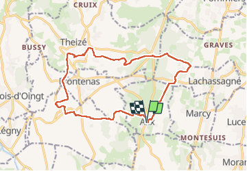
ALIX (16 km - D. 347 m)

Thomasdanielle
User

Length
16.4 km

Max alt
435 m

Uphill gradient
347 m
Km-Effort
21 km

Min alt
271 m

Downhill gradient
348 m
Boucle
Yes
Creation date :
2024-10-21 07:02:30.0
Updated on :
2024-10-23 08:49:37.865
4h47
Difficulty : Very difficult

FREE GPS app for hiking
 SityTrail
IGN / Geographical institutes
SityTrail Plus
The world is yours!
About
Trail Walking of 16.4 km to be discovered at Auvergne-Rhône-Alpes, Rhône, Alix. This trail is proposed by Thomasdanielle.
Description
D/A : Parking place de la mairie face au bar
Positioning
Country:
France
Region :
Auvergne-Rhône-Alpes
Department/Province :
Rhône
Municipality :
Alix
Location:
Unknown
Start:(Dec)
Start:(UTM)
628184 ; 5085551 (31T) N.
Comments