


bêta Aiguebelle Colou

lionelnottat
User

Length
8.7 km

Max alt
1754 m

Uphill gradient
454 m
Km-Effort
14.8 km

Min alt
1354 m

Downhill gradient
456 m
Boucle
Yes
Creation date :
2024-10-19 08:33:22.414
Updated on :
2024-10-21 16:57:38.594
2h55
Difficulty : Difficult

FREE GPS app for hiking
 SityTrail
IGN / Geographical institutes
SityTrail Plus
The world is yours!
About
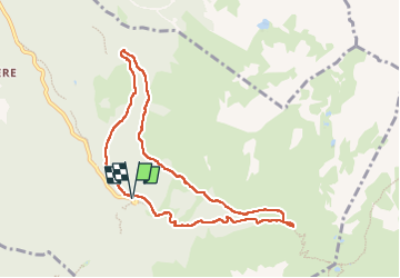
Trail Walking of 8.7 km to be discovered at Auvergne-Rhône-Alpes, Isère, Laval-en-Belledonne. This trail is proposed by lionelnottat.
Positioning
Country:
France
Region :
Auvergne-Rhône-Alpes
Department/Province :
Isère
Municipality :
Laval-en-Belledonne
Location:
Unknown
Start:(Dec)
Start:(UTM)
735396 ; 5012317 (31T) N.
Comments